Drone Surveys · Kent & South East England
Drone surveys that deliver decision-ready site data
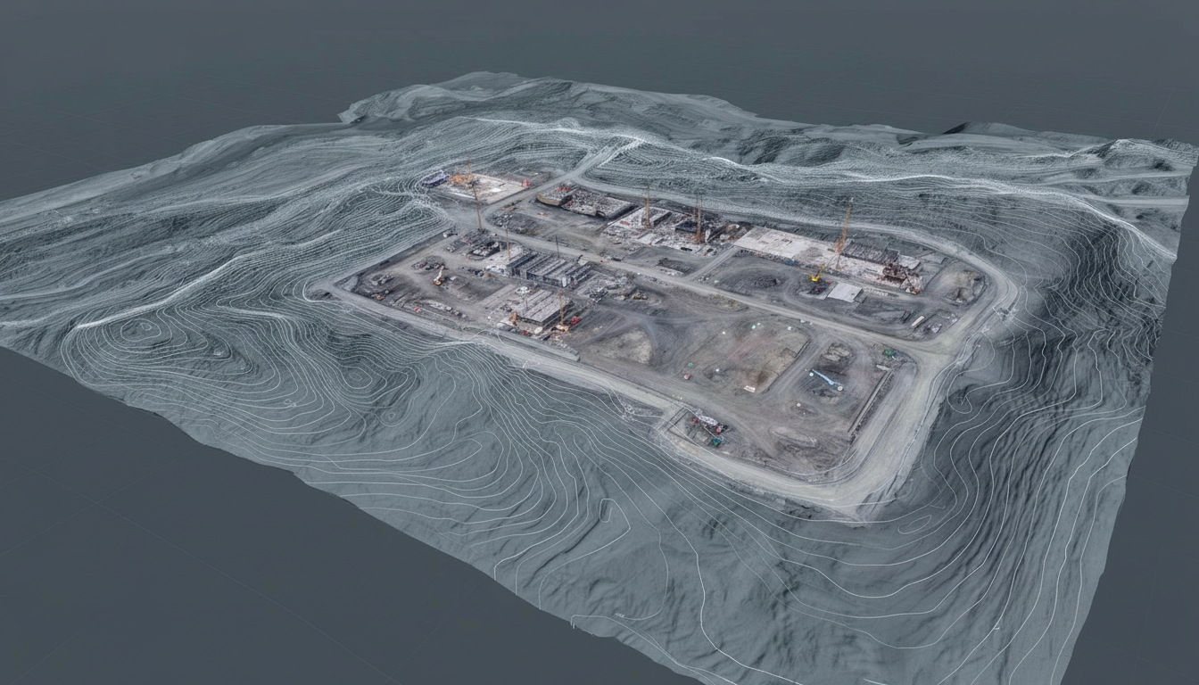
We produce topographic maps, cut/fill volumes, orthomosaics and 3D site models for construction and civil engineering projects across Kent and South East England. Track earthworks progress with accurate, comparable data from each survey. Deliverables are provided in CAD/GIS-compatible formats (GeoTIFF, LAS/LAZ, DXF, SHP/GeoPackage) so your team can import the data straight into your workflow.
Topographic maps & contours
Accurate elevation data for site design, drainage planning, and earthworks. We produce DTM and DSM models with contour lines at your preferred intervals, exported in CAD/GIS-compatible formats for easy import into your software.
Typical outputs:
- Digital Terrain Models (DTM)
- Digital Surface Models (DSM)
- Contour maps (0.25m, 0.5m, 1m intervals)
- Spot height exports
Cut/fill volumes & stockpiles
Measure excavation and fill quantities with confidence. Compare as-built surfaces against design levels to verify earthworks progress, or calculate stockpile volumes for material management and invoicing.
Common applications:
- Stockpile volume reports
- Cut and fill balance calculations
- Quantity verification for claims
- Monthly progress comparisons
Orthomosaics
High-resolution, georeferenced aerial imagery stitched into a single, measurable map. Orthomosaics provide an accurate visual record of your site for planning, measurement, and documentation—delivered as GeoTIFF files ready for GIS import.
Key benefits:
- True-to-scale site imagery
- GeoTIFF format for GIS import
- Measure distances and areas directly
- Visual baseline for change detection
3D site models & progress tracking
Visualise your site in 3D for planning, coordination, and stakeholder communication. Regular surveys create a visual record of progress, helping you track changes, identify issues early, and document work completed.
Deliverables include:
- Textured 3D mesh models
- Point clouds (LAS/LAZ format)
- Progress comparison reports
Environmental mapping (NDVI / Multispectral)
Multispectral drone surveys reveal vegetation health patterns invisible to the eye. NDVI and NDRE indices help land managers, environmental consultants, and ecologists assess condition, establish baselines, and monitor change over time.
Use cases:
- Vegetation health assessment
- Habitat condition surveys
- Environmental baseline reports
- Seasonal change detection
Who uses drone surveys?
Our clients include groundworks contractors, civil engineers, site managers, developers, and environmental consultants who need reliable site data without traditional surveying delays.
Common project types:
- Housing developments and residential builds
- Road and infrastructure projects
- Quarries, landfill sites, and aggregate storage
- Solar farm installations and land assessments
How it works
From initial flight to final deliverables, we handle the entire survey process:
1. Fly
We capture high-resolution aerial imagery of your site using professional drone equipment. Flights are planned for optimal coverage and accuracy.
2. Process
Imagery is processed using photogrammetry software to generate georeferenced orthomosaics, elevation models, and 3D outputs.
3. Deliver
You receive your data in CAD and GIS-compatible formats within 24–48 hours, ready to use in your existing workflows.
Request a site survey
Get a quote for drone surveying on your construction site in Kent or South East England. Fast turnaround, accurate data, CAA authorised operations.
View all services About us Contact
Get a Quote